


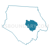
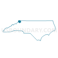
Voting District 09, Ashe County, North Carolina
About
Outline

Summary
| Unique Area Identifier | 639301 |
| Name | Voting District 09 |
| County | Ashe County |
| State | North Carolina |
| Area (square miles) | 33.02 |
| Land Area (square miles) | 32.63 |
| Water Area (square miles) | 0.39 |
| % of Land Area | 98.82 |
| % of Water Area | 1.18 |
| Latitude of the Internal Point | 36.41496520 |
| Longtitude of the Internal Point | -81.42703130 |
Maps

Graphs
Select a template below for downloading or customizing gragh for Voting District 09, Ashe County, North Carolina


Neighbors
Neighoring Voting District (by Name) Neighboring Voting District on the Map
- Voting District 11, Ashe County, NC
- Voting District 13, Ashe County, NC
- Voting District 15, Ashe County, NC
- Voting District 20, Ashe County, NC
Top 10 Neighboring County Subdivision (by Population) Neighboring County Subdivision on the Map
- Jefferson township, Ashe County, NC (4,718)
- West Jefferson township, Ashe County, NC (4,614)
- Obids township, Ashe County, NC (1,376)
- Walnut Hill township, Ashe County, NC (1,369)
- Peak Creek township, Ashe County, NC (1,104)
- Chestnut Hill township, Ashe County, NC (828)